Aotea Great Barrier Island sits 90km northeast of Auckland and operates on a completely different set of rules. No traffic lights. No McDonald’s. No 4G. Around 1,200 permanent residents. DOC manages a huge chunk of the land. The power grid doesn’t reach here — everything runs on solar, wind, and diesel.
It is, by most modern definitions, inconvenient. It is also one of the best places in New Zealand.
Here’s what to do when you get here.
Contents
- Beaches
- Walks & Hikes
- Exploring the West Coast
- Surfing
- Water Activities
- Food & Drink
- Arts & Culture
- Wildlife
- Events
- Stargazing
- Practical Tips
- Camping
- Where to Stay
Beaches
Great Barrier has two completely different coastlines. The east coast faces northeast into the Hauraki Gulf — long exposed beaches, white sand, consistent surf, almost nobody on them. The west coast is sheltered harbour country: calm water, mangroves, mussel farms, and coves better suited to a kayak than a surfboard. Most visitors spend most of their beach time on the east coast. Most visitors also barely scratch the surface of what’s there.
East Coast Beaches
Medlands Beach
The headline act. Medlands runs 1.5 kilometres of white sand along Oruawharo Bay, facing northeast. It’s the closest surf beach to Tryphena, six minutes from Claris Airport, and where most east coast visits start and end.
The sand is fine and white — not the grey gritty stuff that ends up on mainland west-coast beaches. The water is clean. The northeast aspect puts the beach in a wide swell window — NE, E, and SE groundswell all reach here. See the Surfing section for conditions detail.
Memory Rock sits mid-bay, a volcanic formation reachable at any tide. The seaward face has a natural stepped profile — climbable if you’re sure-footed — with a rock pool on the seaward side at low tide. The top gives you the full panorama: the bay in both directions, the dunes behind, the ranges inland.
At the southern end the beach gives way to the Oruawharo Creek estuary — shallow, calm, sheltered by dunes, and safe for kids and non-swimmers. The DOC campground sits directly behind the dunes here: 120-person capacity, $18/night adult, toilets and cold showers. It books out fast in summer (bookings.doc.govt.nz; 2026/27 bookings open 14 May 2026).
Aotea Brewing is five minutes’ walk on Mason Road. 175° East — three off-grid solar-powered houses sleeping large groups — is the closest accommodation, an eight-minute walk to the sand.
On a busy summer day at Medlands, you might share the beach with thirty people spread across a kilometre and a half. In winter, probably nobody. For a beach of this quality — 1.5km of white sand, consistent surf, a feature rock you can climb, a safe estuary at one end, a craft brewery five minutes away, and a DOC campsite in the dunes — the crowd numbers alone make the case. There’s nowhere else in the Hauraki Gulf that puts this many specific things in one place.
Brown teal (pāteke) and NZ dotterel nest here. Give them space during breeding season.
Kaitoke Beach
Runs from the Sugar Loaf headlands at its southern end to the Kaitoke Stream and swamp in the north — another long, northeast-facing sandy bay. Same general swell window as Medlands, consistent surf year-round, left and right breaks, rarely crowded. The Aotea Board Riders Club holds competitions here. Note the advisory on the official destination listing: rips and sharks. These waters have both.
Dark mountain backdrop, sparkly white sand. Rock pools at the southern end (the “mermaid pools” in Wikivoyage’s description) worth checking at low tide. Access via Ocean View Road (mid-beach) or Sugarloaf Road (southern end). The private Sugarloaf Campground is at the southern end — better shelter than the exposed DOC sites.
Brown teal and dotterel nesting ground. Standard rules: keep clear during breeding season.
Palmers Beach
East coast surf beach immediately north of Kaitoke, reached by continuing past the creek at Kaitoke’s northern end. No campsite, no facilities. Hammerhead sharks are occasionally spotted offshore — reportedly more visible from the air than the sand.
Awana Bay
About 10 minutes north of Claris on Aotea Road. One of the island’s most popular surf beaches (DOC’s words). Longer and more exposed than Medlands, slightly more northerly in aspect — picks up swell components that miss Medlands when they arrive from a steep NE angle.
The DOC campsite sits beside the Awana Estuary at the northern end: 120-person capacity, picnic shelter, 300m walk to the beach. Bring mosquito repellent — the estuary earns it. Brown teal, dotterel, oystercatcher, and banded rail all nest here.
Harataonga Beach
Reached via Harataonga Road, roughly midway up the east coast. DOC confirms it’s good for snorkelling and swimming. The beach has been used as a TV filming location — which tells you something about how the setting reads on camera.
The DOC campground sits between two streams, sheltered under mature trees, 300m from the beach on a narrow gravel road. Good fishing. Māori historic sites and settler graves in the area. Best for a full day with the campsite as base: snorkelling, swimming, walking the Harataonga Coastal Track.
Northern Beaches
Whangapoua Beach
At the northern end of the island near the Okiwi airfield, on Mabey Road. North-facing rather than northeast — different swell window to the east coast beaches, requiring a northerly swell component to fire. DOC describes the DOC campsite here as close to “a popular surf beach” and it consistently shows up in surf and camping resources as the spot for northern island beach camping.
The wider setting is genuinely good: views across the Whangapoua Estuary to Rakitu Island, with Mt Hirakimata (Mt Hobson) behind. Long sandy beach, rock formations about 500m south of the dune crossing worth exploring.
At the northern end, a short walk leads to the Wairarapa Graves — the burial site for some of those drowned when the SS Wairarapa ran aground at Miners Head on 29 October 1894, New Zealand’s worst maritime disaster. The Wairarapa Graves Walkway runs from the campsite.
Campsite: 150-person capacity, edge of estuary, $18/night. Boil water before drinking (DOC advisory). No fires.
West Coast & Harbour Beaches
The west coast is sheltered, which means flat water and a completely different mood. None of these beaches have the surf or sand quality of the east coast. What they have is calm, good fishing, and the kind of scenery that rewards kayaking rather than swimming.
Akapoua Bay (near Port Fitzroy) — sheltered family camping area, easy water access for kayaking and light fishing. DOC campsite with car/campervan access and an exclusive-use DOC cottage available October–May. Good base for northern walking tracks.
Whangaparapara Harbour — not a swimming beach. The whaling station ruins sit on the northern shore. The DOC Green campsite (15 tents, popular with Aotea Track trampers) is here but the draw is the industrial history rather than the water. The wharf is one of the best wharf-jumping spots on the island for kids.
Southern Beaches
The Tryphena cluster in the south has sheltered harbour-facing beaches. These are calm-water beaches, not surf beaches.
Puriri Bay — sheltered bay off Puriri Bay Road, Tryphena. Protected from the open gulf. Safe swimming, calm water, good for an evening in the water. Tipi & Bob’s Waterfront Lodge is here.
Since January 2026 it’s also home to Finny’s — a bespoke Airstream-style food caravan run by local Peter Boardman. Fish and chips cooked in tallow (gurnard, orange roughy, prawns), fish sourced with full provenance, and a “catch and cook” option: hire a kayak or paddleboard, head out into the bay, bring back your catch, and Peter and chef Lola will cook it on the spot. Dog-friendly, coffee available, right by the boat ramp. Open Friday–Sunday 1–7pm, weather dependent.
The Elephant Gallery (local gallery owner Marion Davison) is nearby and stays open until 6pm on Finny’s days — worth combining the two.
Shoal Bay — near Tryphena, off Shoal Bay Road and Cape Barrier Road. Sheltered, calm. The Stray Possum Lodge is a short walk away. Good for a quiet swim without the surf.
Okupu Beach — Camerton Road, west-facing across the inner harbour. Calm water, dolphins regularly close to shore, public BBQ on site. The wharf is excellent for wharf jumping — one of the best on the island for kids. Good for a sunset BBQ too: bring your own supplies, not a surfing beach, and the evening is better than midday. One of the better casual-afternoon options in the south.
Tryphena Bay itself has safe swimming and decent fishing. Fine for a post-dinner paddle.
A Note on Getting There
Most beaches on this island are reached by unsealed roads. Medlands, Kaitoke, and Awana are accessible in a standard rental car. Harataonga and most northern and west coast options benefit from higher clearance and preferably some local knowledge about road conditions after rain. Download offline maps before leaving Claris or Tryphena — mobile coverage drops out quickly off the main road, and many beaches are in dead zones.
Walks & Hikes
Station Rock Lookout
The most underrated walk from the Medlands end of the island. Trailhead is at the top of Medland Road — twenty minutes up, twenty back, minimal effort, and the view opens over Oruawharo Bay in a way you don’t get from the beach itself. Do it in the evening when the light is low and the beach is still below you. It doesn’t need a full afternoon.
Windy Canyon
The best short walk on the island. From the Aotea Road carpark, it’s steep for the first stretch, and then you’re in it — sheer volcanic walls, compressed sky, the island’s geological skeleton made visible. The canyon opens onto a ridge where a century-old wooden H-frame still stands in the bush: the winch the Kauri Timber Company used to haul logs up and over the saddle in the 1920s. From the upper edge, the view splits in two directions — north over the flat Okiwi Basin and Whangapoua estuary, east down to Kaitoke and Medlands beaches from height. Allow about an hour for the full experience. Bring a jacket. The name isn’t ironic.
Kaitoke Hot Springs
Easy | ~3km return | 1.5–2 hrs including time at the pools | Trailhead: Whangaparapara Road
The track starts flat across the Kaitoke Wetlands — boardwalks over waterlogged ground, kānuka overhead, native orchids and sundews close to the track edge if you’re looking for them. Fernbirds call from the margins. After about 30–40 minutes the forest thickens and the sulphurous smell arrives before the pools do. They’re dammed at a fork in Kaitoke Creek, ringed with umbrella fern, with a picnic table and toilet at the main pool. The temperature varies depending on where you sit — the hot spring meets the cold creek and you find your own compromise. Five minutes further upstream: hotter, more enclosed, fewer people.
DOC-managed, free. Go in winter — the contrast between cold air and warm water is the actual experience. Summer afternoon queues are real; early morning or late afternoon are better.
Warning: pool water can be very hot in places. DOC advises do not submerge your head.
Kowhai Track
One-way | ~1.5 hrs | Mostly downhill from Rosalie Bay to Medlands Beach
This one is worth knowing about if you’re based at Medlands. The track starts at the top of Rosalie Bay Road in the south and descends — mostly downhill through bush — arriving at Medlands Beach. Arrange transport to the Rosalie Bay end and walk down to your accommodation. Not widely advertised, not crowded, and you finish at the best beach on the island.
Te Ahumata / White Cliffs
Easy to Intermediate | ~2 hrs return including summit | Trailhead: Blind Bay Road or Whangaparapara Road
The White Cliffs are a landmark visible from Medlands Beach — the pale limestone face above the middle of the island. The track runs between Blind Bay Road and Whangaparapara Road (either end), with a side track to the 398m summit. Thirty minutes from either end gets you to the junction; another thirty to the top. At the summit: 360-degree views over Claris, both coastlines, the Whangaparapara Harbour, and the island’s spine. A good aerobic walk that earns its views without requiring a full day.
Mount Hobson — Hirakimata
Intermediate | 4–5 hrs return | Trailhead: Aotea Road (Windy Canyon)
The island’s highest point at 621 metres — and the best all-day walk. The route via Windy Canyon and Palmers Track is the most accessible entry: well-bridged, clear track, and it takes you through the canyon on the way up. The summit gives you the full Gulf — Coromandel, Northland, Little Barrier Island (Hauturu), the Poor Knights on a clear day.
At the top: wooden steps protect the black petrel nesting burrows. These birds spend months at sea flying as far as South America and return to this specific ridgeline to breed, October through May. The island’s endemic Great Barrier tree daisy grows near the summit. It’s a working ecosystem up there, not just a viewpoint.
Cloud moves fast on the summit. Start early, check the weather, and don’t commit to the full day if the upper ridges are socked in.
Aotea Track
2–3 days | Intermediate | Hut bookings essential
The island’s multi-day trail through the interior — native forest, ridgelines, both coasts from elevation, and 80 years of logging history written into the landscape. It is a serious tramp: good boots, full weather kit, hut bookings required.
Two DOC huts:
Mt Heale Hut (20 bunks) — reached via Windy Canyon and Palmers Track, about 3–3.5 hours from Aotea Road. Two deck areas with sweeping views of the Hauraki Gulf and Hauturu/Little Barrier Island. $25/night adults.
Kaiaraara Hut (28 bunks) — wood stove, gas cooking. Below the hut, the foundation timbers of a 1920s kauri dam are still visible in the streambed. The dam once propelled an estimated 7 million board feet of timber into Kaiaraara Bay. A 5-minute detour off the final day’s route passes Kauri Falls — worth it. $25/night adults.
2026/27 season bookings open 12 May 2026 at noon — book the moment they go live.
Harataonga Walks
Two separate walks operate from the Harataonga area on the east coast, and they’re easily confused:
Harataonga Loop Walk (~1 hr, Easy to Intermediate) — good views into the bays, an old Māori pā site, steep descent on the last section. Accessible for most people in a morning.
Harataonga Coastal Walk (~5 hrs one way, Intermediate) — runs the full coastline from Whangapoua to Harataonga through mature pōhutukawa. One of the longer bush walks on the island. Requires a car shuttle or transport arrangement — you end up at a different end from where you started. Go Great Barrier Island transport (09 429 0222) runs track pick-ups.
Tramline Track
Advanced — fit trampers only | Minimal upkeep
The Kauri Timber Company’s tramline from the 1920s–30s — sometimes very steep, crosses several creeks, and receives minimal DOC upkeep. This is not a family day walk. The shorter approach from the Whangaparapara end reaches Forest Road in about an hour and gives the flavour of the thing without the full commitment. The Pack Track connecting to this route is permanently closed.
Glenfern Sanctuary
Easy | 2km loop | Free | Open daily from 10am
On the northwest coast near Port Fitzroy — 83 hectares of Regional Park and the gateway to the predator-fenced 240-hectare Kōtuku Peninsula. The birdcall inside the fence is noticeably different from outside. Brown teal, chevron skink (found almost nowhere else), kākā, kākāriki. A highlight is a climb up into the crown of a mature kauri tree. The 1901 Fitzroy House is on the grounds and the headland views over the Gulf are worth the drive.
Managed in partnership with Ngāti Rehua Ngātiwai ki Aotea, the mana whenua of Aotea.
Exploring the West Coast
The east coast gets the visitors. The west coast gets the history. The two main settlements here — Whangaparapara and Port Fitzroy — are worth the drive.
Whangaparapara
About 45 minutes from Claris by road, Whangaparapara was the island’s industrial engine room for a century. Gold and silver were discovered here in the late 1800s. The Kauri Timber Company ran a sawmill that was, at its peak in the early 1900s, reportedly the largest in the southern hemisphere. Then came the whalers.
New Zealand’s last operational whaling station ran at Whangaparapara from 1957 to 1962 — the ruins of it still sit on the northern side of the harbour. This is not ancient history. It closed two years after the Beatles released their first single.
What’s still visible today:
- The Oreville stamping battery — the ore-crushing machine from the mining era is still standing on Whangaparapara Road. Hard to miss, worth stopping for.
- The whaling station remnants — on the northern harbour foreshore. No signage glamourises it. The rusting infrastructure is just there, slowly returning to the landscape.
- SS Wiltshire anchor — visible on the grounds of Great Barrier Lodge. The Wiltshire ran aground at Rosalie Bay on the island’s southern end in 1922.
Hooked On Barrier (hookedonbarrier.co.nz) runs fishing and boat charter trips out of Whangaparapara Wharf — their West Coast Tour runs five hours with morning tea and lunch on board, from $230. The DOC campsite (The Green) is also here — 15 tents maximum, popular with Aotea Track trampers.
Port Fitzroy
The main settlement on the west coast and the northern SeaLink ferry terminal. It’s about 35 minutes from Claris, and worth the trip even if you’re not arriving by boat.
Port Fitzroy Store (Mon–Sat, 9am–5pm) is the only shop in North Barrier — groceries, fresh produce, meats, bottle shop, EFTPOS, and a Post Shop. If you’re tramping the northern section of the Aotea Track, stock up here. The store is a short walk from the wharf and gets boaties, trampers, and locals through its doors daily.
The wharf itself is a good spot to watch the harbour and catch the SeaLink arrival if you’re meeting someone. The northern trailhead for the Kaiaraara Hut section of the Aotea Track starts near here. Glenfern Sanctuary is a short drive away.
Fishing charters also operate out of Port Fitzroy — ask at the store or contact Hooked On Barrier directly.
Surfing
Great Barrier’s northeast-facing coastline puts it in the path of consistent NE, E, and SE groundswell year-round. Four surf beaches — Medlands, Kaitoke, Awana, and Whangapoua — each with a slightly different aspect and swell window, mean there’s usually something breaking somewhere on the island regardless of the forecast.
Medlands is the main event: left and right handers, an 8-minute walk from 175° East, and rarely more than a handful of people in the water. Kaitoke is longer and more exposed. Awana picks up angles that miss Medlands on steep NE swells. Whangapoua in the north has a different window entirely and rewards the drive when conditions align.
These are real beaches with rips. Strong intermediate to experienced surfers will find them excellent. Board hire on the island is limited — bring your own if you’re serious about it.
→ Full guide: Surfing on Great Barrier Island — breaks, conditions, and what to know
Water Activities
Kayaking & Snorkelling
The water around Aotea is clear and relatively undisturbed — the benefit of an island with minimal run-off and no industrial activity. Aotea Kayak Adventures (run by Wayne Anderson) offers single and double sea kayaks for hire, including guided multi-day coastal trips. The sheltered bays on the western side of the island are the best for flat-water paddling. For snorkelling, the rocky headlands around Katherine Bay and the northern coast offer good visibility and marine life. Visibility drops after rain, so pick a settled day.
Diving
Great Barrier has some of the best diving in the Hauraki Gulf. The Broken Islands, off the northeastern coast, are a marine reserve with exceptional fish life and visibility. Contact local dive operators for guided trips — it’s not the kind of place you want to wing on your own unless you know these waters well.
Fishing
People fish here seriously. The waters around Aotea hold snapper, kingfish, kahawai, and more. Hooked On Barrier (hookedonbarrier.co.nz) runs fishing charters out of Whangaparapara — half-day and full-day options, guided by skippers who know where the fish are. Or fish off the rocks. Or from the beach at Medlands in the evening. Nobody’s going to stop you.
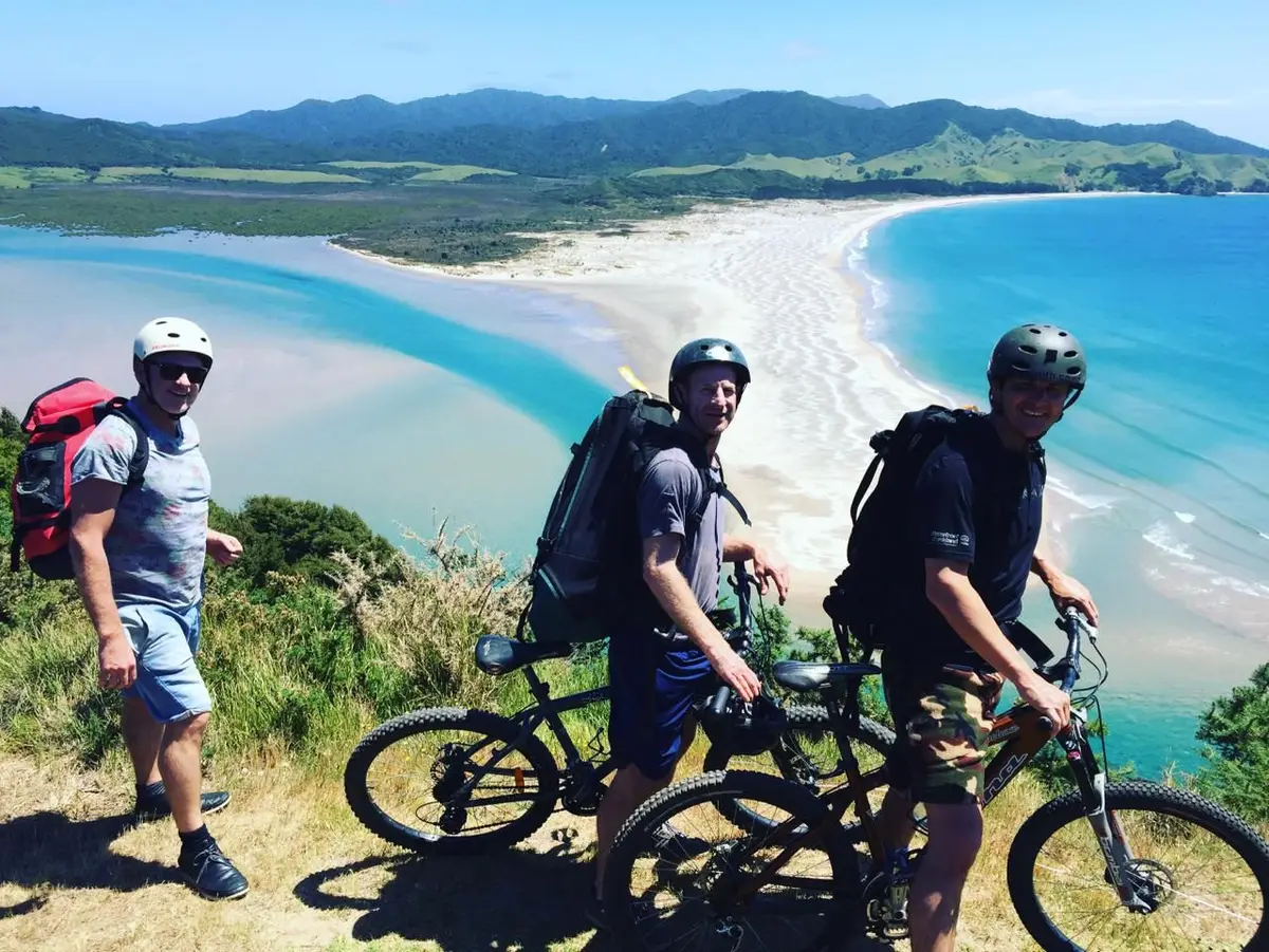
Mountain Biking
The island’s road network and DOC tracks offer genuinely good riding — technical in places, always scenic. Motubikes offers e-bike and mountain bike hire — useful whether you’re getting between trailheads or just exploring the east coast road at your own pace. The route from Claris through to Whangaparapara gives you estuary views, forest, and hills in a single loop. Ask your accommodation or check with Motubikes for current track conditions before heading out.
Food & Drink
Aotea Brewing
Walk-in distance from Medlands Beach — about five minutes on foot. A solar-powered craft brewery in a converted shipping container on a farm paddock. Zero-waste philosophy: no bottles, no cans — bring a flagon or buy one there and fill it fresh from the keg. The Solar Charged APA is the island staple; the Daily Grind coffee stout (made with beans from next-door Aotea Roast) is worth seeking out. Open Thursday to Sunday, 12–6pm. One of those places that feels completely right for where it is.
Aotea Roast
Next door to Aotea Brewing at the Mason Rd Hub — New Zealand’s first off-grid coffee roastery. Small-batch, fair trade, organic, roasted on renewable energy on a remote island in the Hauraki Gulf. You can order online and have it delivered to the mainland, but it tastes better here.
Island Gin
Started at a small bach at Medlands Beach, where founder Andi Ross spent summers experimenting on a copper pot still with local ingredients. The result is an internationally awarded gin built around Great Barrier Manuka and bush honey — solar distilled, rainwater filtered, and bottled in a kina-inspired vessel made from recycled New Zealand glass. Tastings by appointment for groups of up to six (call 0274 752 637). Bottles available at The Rocks bottle shop and Stonewall Store.
Finny’s, Puriri Bay
Fish and chips cooked in tallow from a bespoke Airstream caravan at the Puriri Bay boat ramp, Tryphena. The menu runs to fresh gurnard, orange roughy, and prawns — every fish comes with a sourcing story. The standout option is their “catch and cook”: hire a kayak or paddleboard, catch something in the bay, and bring it back to be cooked on the spot. Dog-friendly, coffee available. Open Friday–Sunday 1–7pm, weather dependent. Opened January 2026 — already a local institution.
The Currach Irish Pub
In Tryphena, about 25 minutes south of Medlands. The social centre of the island’s visitor scene — live music, cold Guinness, and the kind of pub where you end up talking to a local until closing time without meaning to. Go on a Friday or Saturday night if you can. Quiz night Sundays. Open mic/jam night Thursdays from 8pm. Check currachirishpub.co.nz for the current live music schedule.
Claris
The closest thing Great Barrier has to a town centre. There’s a general store, a café, a bottle shop, a post shop, and a laundrette. You can get everything you actually need and not much more. Stock up on wine and groceries here before heading to remote accommodation — don’t assume you can pop out.
Great Barrier Island Sports Club
At the start of Whangaparapara Road, 200m from the Crossroads. Touch footy, rugby, tennis, cricket, pool, table tennis, darts — and a fully licensed bar with kitchen serving proper meals. Open from 4pm Wednesday, Friday, and Saturday. If you want to actually meet locals rather than just wave at them, this is the place.
Great Barrier Island Golf Club
The 9-hole course at Pioneer Park, Whangaparapara Road sits in the bowl between Te Ahumata (the White Cliffs) and Hirakimata (Mt Hobson) — about five minutes from Claris airport, and a genuinely pleasant stretch of course maintained entirely by volunteers.
The layout plays as a true 9-hole, but the second nine uses different tee blocks, so you get an effective 18-hole round. Visitors are welcome any day.
- Green fees: $25 (honesty box on non-club days)
- Club + trundler hire: $25
- Club days: Thursday and Sunday — clubhouse open with drinks and light snacks
- Contact: [email protected] / Ph 09 4290 420
If you’re deciding whether to pack your clubs: yes, pack them. The course is good, the setting is exceptional, and the post-round drink situation is sorted.
Arts & Culture
The island’s creative output is disproportionate to its population. You can spend a real afternoon here without going near a beach.
Anamata Community Hub
Anamata is the island’s community recycling and resource recovery centre — and one of the more unexpectedly interesting stops on Aotea. It runs a second-hand shop and sells upcycled goods made from donated and recovered materials. What ends up on those shelves is a direct reflection of what 1,200 resourceful, off-grid people make, repurpose, and create when they can’t just drive to Bunnings.
The creativity on display isn’t curated or performative — it’s practical ingenuity made visible. Worth a visit if you want to understand the island rather than just pass through it.
66c Gray Road, Aotea/Great Barrier Island | +64 09 4290 654 | anamata.nz
Opening hours: Wed–Fri 9am–4pm, Sat 10am–3pm. Closed Sundays and public holidays.
Aotea Arts & History Village
At 80 Hector Sanderson Road, Claris — the island’s main arts institution. Gallery, museum, and gift shop under one roof, open daily. The gallery shows work by local and visiting artists; the museum covers the island’s cultural history. The gift shop sells locally made work rather than the usual tourist fare. Good stop before or after the airport if you’re on a tight schedule.
Find them on Facebook at @GBIARTGALLERY or email [email protected].
Elephant Gallery
Marion Davison’s gallery at Puriri Bay, Tryphena — local and visiting artist work in a setting that makes sense for the island. Worth combining with a trip to Finny’s (next door); Marion keeps the gallery open until 6pm on Finny’s days specifically for that reason. Check locally for current hours.
Milk, Honey & Grain Museum
A small, hands-on history museum on the main road into Claris — David Watson has been an island resident long enough to have collected an extraordinary amount of the place’s material history. Entry is by gold coin donation.
The themes run wide: dairying, gum digging, logging, timber milling, mining, bee-keeping, shipwrecks, long drops, and whaling. Visitors are explicitly encouraged to turn handles, pull drawers, and fossick through the artefacts. It’s the kind of museum where you walk in expecting 20 minutes and stay an hour.
Open most days — call ahead to confirm (the sign outside will usually tell you). Alongside Wiltshire Manor Backpackers, close to the Claris airfield.
Wildlife
This is one of the most ecologically significant islands in New Zealand and most visitors barely scratch the surface.
Birds: Over 60% of NZ’s entire brown teal (pāteke) population lives on the island. North Island kaka — the large native parrot — are common and loud. Black petrel nest on the upper ridges of Hirakimata (Mount Hobson), which holds the main nesting colony in New Zealand. Banded rail, spotless crake, fern bird, and NZ dotterel are all here. If birds are your thing, this island is a serious destination.
Lizards: Aotea has over 13 species of lizard, including the chevron skink — the rarest skink in the region and found almost nowhere else. You’re unlikely to see one unless you look carefully in the right spots, but they’re here.
Marine life: Dolphins are regularly spotted in Tryphena Harbour and off the west coast. Orca pass through. NZ fur seals haul out on the northern rocks. The waters are cleaner and richer than most of the Hauraki Gulf. Snorkellers and divers regularly encounter large snapper, crayfish, and schooling fish in the marine reserve areas.
The DOC estate covers a huge portion of the island — if you see native bush, assume there’s something worth protecting in it.
Events
FitzRoy Mussel Fest — an annual celebration of the mussels Port Fitzroy is known for. Good food, local atmosphere, the kind of event that makes you realise how good island life can be.
Wharf2Wharf — a marathon-length event where athletes walk, run, or cycle across the island. If you’re here when it’s on, the whole island turns out.
Garden Tour — the Great Barrier garden tour showcases the island’s stunning residential gardens. Genuinely surprising — the gardens people have built in this environment are extraordinary.
Check current dates before you travel — island event calendars shift year to year. greatbarrier.co.nz carries the most up-to-date listings.
Stargazing
Great Barrier Island is one of a handful of places on Earth designated an International Dark Sky Sanctuary. There is no light pollution. On a clear night, the Milky Way is not a faint smudge — it’s a proper structure you can watch your eyes adjust to.
No special equipment required. Just go outside after dark, let your eyes settle for ten minutes, and look up. The full guide to the dark sky sanctuary covers the best spots and what you’re actually looking at — worth reading before you arrive.
The best stargazing is away from Claris (the only meaningful light source on the island) and on nights with no moon. Check the lunar calendar before you book if this matters to you.
At 175° East, we have Starlink — fast satellite internet that works — but we’d still recommend spending at least one evening offline under those skies.
Practical Tips
Getting here: Fly with Barrier Air in 35 minutes from Auckland, or take the SeaLink ferry from Wynyard Quarter (4.5 hours, scenic, you can bring your car). Book early — summer sailings with vehicles sell out months in advance.
Getting around: No public transport. Hire a car at Claris Airport or Tryphena Wharf, or bring your own. Roads are narrow and mostly unsealed. An island-friendly vehicle is not optional — it’s how you get anywhere interesting. Motubikes offers e-bike and mountain bike hire if you want two wheels instead of four.
Connectivity: Mobile coverage is patchy. 4G doesn’t exist. Download your maps offline before you leave the mainland. Tell someone your plans if you’re heading anywhere remote.
Money: Bring cash or EFTPOS. Card acceptance is not universal. ATMs are limited.
Supplies: Stock up in Claris or Tryphena when you arrive. If you’re heading to the west coast, the Port Fitzroy Store (Mon–Sat, 9am–5pm) is the only option in the north — plan around it. The stores carry what you need, but selection is limited and hours vary. If you’re staying somewhere remote, treat it like camping — plan your meals and bring what you’ll need.
Weather: The island is exposed. It can be brilliant one hour and blowing sideways the next. Pack a layer regardless of the season. Winter is genuinely underrated — fewer people, incredible stargazing, and the island at its most itself.
Camping
Great Barrier has some of the best camping in New Zealand. Most sites are DOC-managed — basic but beautiful. Book early for summer, especially Christmas/New Year.
DOC campgrounds (book at bookings.doc.govt.nz):
- Medlands Beach — right behind the dunes at Medlands, sheltered and sunny. Closest to the action. Books out fast in summer.
- Harataonga — remote, set under mature pōhutukawa, short walk to Harataonga Beach. Excellent fishing. One of the quieter, more beautiful sites on the island.
- Awana Beach — tucked beside the Awana estuary, 10-minute walk to the surf beach. Popular with surfers and younger groups.
- Akapoua Bay — sheltered harbour-side site near Port Fitzroy. Great for fishing, good base for north island walking tracks.
- Whangapoua — more exposed, but stunning views of Rakitu Island and Mount Hobson. Close to the Okiwi airstrip. Popular with surfers.
- The Green (Whangaparapara) — smallest DOC site (15 tents only). Very popular with trampers doing the Aotea Track. 15 minutes walk from Great Barrier Lodge.
No open fires at any DOC site — bring a gas cooker. No dogs.
Private:
- Sugarloaf Campground — private site at the southern end of Kaitoke Beach. Good shelter, privacy, Macrocarpa trees. One of the better private options.
- Great Barrier Island Campground (Tryphena) — 12 acres, 200m from the beach, harbour views. Eco toilets, showers, $10/person/night. Contact: 021 298 8905.
Where to Stay
The island has camping (DOC sites), lodges, holiday homes, and baches. If you want to be at Medlands Beach — the best beach on the island, 35 minutes from the Auckland airport — 175° East has three off-grid solar-powered houses: Pītokuku, Ruru, and Tree House. All sleep large groups, all are fully equipped, and all are an 8-minute walk from the sand.
No platform fees. Book direct.
Great Barrier Island doesn’t try to impress you. It doesn’t have to. Show up with the right expectations — which is to say, low ones for convenience and high ones for everything else — and it’ll exceed them.
Planning your trip? Start with the complete guide to getting to Great Barrier Island — flights, ferry, car hire, and what to expect on arrival.